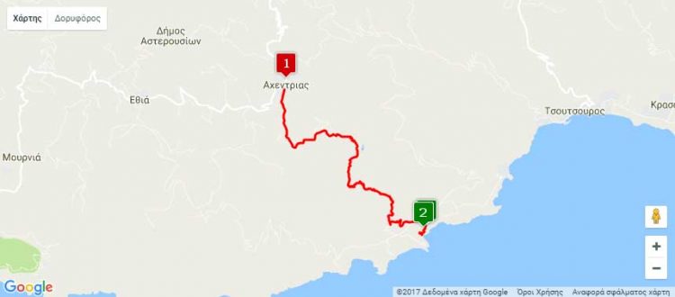
Nearest hamlets: Achentrias, Maridaki
Distance: 8km
Duration: 3 hours
Entrance coordinates: 34° 58.938’N / 25° 14.127’E (Achentrias – Steiromantra)
Exit coordinates: 34° 57.956’N / 25° 15.345’E (Agios Nikitas Monastery)
Trail type: Goat path without markers
Difficulty: Moderate. Experience in trekking is required, as the path is not clearly visible
Recommended season: Spring, summer, autumn (beware of rainfall and high temperatures)
Amenities: Cafés at Achentrias ‘Kefalovrisi’ spring, monk cells available for tourists at Agios Nikitas Monastery (following arrangements with the caretaker, the only permanent resident at the monastery)
This is one of the most interesting trails in the Asterousia Mountain Range, which has always connected Achentrias with Agios Nikitas Monastery. Follow the southernmost dirt road leading out of the village and park at ‘Steiromantra’, where the road ends. This is where the hike starts, heading SE, up the rise through ‘Stenos Poros’; at the top you can make out the small seasonal lake, ‘Tourkou Lakkos’. After the lake, continue heading SE trying to locate the traces of the old trail. Until the point where the steep slope begins, look for markings on the rocks that will make things easier for you. From then on, there are fewer markings; looking down you can make out the green strip of the palm forest that is your destination. It is where you can find ‘Kefalovrysi’ [a water spring] and Agios Antonios Chapel. The trail ends at the dirt road that you must follow to reach Agios Nikitas Monastery, where you can spend the night, as you can also do on the deserted beach, which the steps immediately beneath the monastery lead to.
Download the kml file of the route in your device: (kml) Achentrias – Agios Nikitas Monastery
source: archanes-asterousia.gr

